|
|
- Dredging
- Economic Development
- Greenways
- Public Safety
- Stormwater
- Urban Infill
COMMITTEE WORKING GROUP | ERIC BUERMANN, CHAIR
dredging |
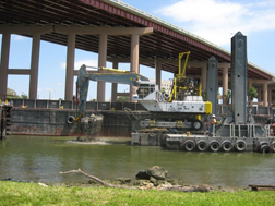
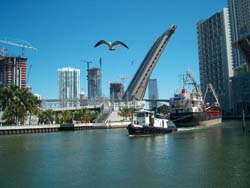
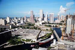
Dredging is slated to resume Feb. 15, 2008 between the 22nd Avenue and 17th Avenue bridges, where the 40-percent-complete project was temporarily demobilized in late 2005.
This is the first maintenance dredging of the Miami River. It restores the federal navigable channel to its authorized depth of 15 feet. Federal, state and local governments have spent $38 million on the project, and utility companies have spent $55 million to relocate lines to the appropriate depth beneath the federal navigable channel for dredging.
This still leaves the $86 million project with a shortfall of roughly $10 million. That money must be provided to the Army Corps of Engineers by July 31, 2008, for the dredging to conclude as budgeted and contracted.
The county has requested $10 million from the Florida Legislature, and the South Florida Water Management District is applying for $3 million from the Florida Inland Navigational District (FIND).
Restoring the river’s federal navigable channel allows vessels to fill cargo to full capacity and traverse regardless of tide, thereby increasing international trade, commerce and local employment. In addition, removing contaminated sediments will improve the natural environment of the Miami River and Biscayne Bay.
|
Dredging Benefits
1. The
River will be environmentally restored and prevent
further degradation to Biscayne Bay.
2. The
shipping industry will expand as ships will be less
dependent on high tide sailings and could transit at most times of the
day and night. This will increase the estimated $4 billion dollars of
goods now being transported via the river and improve the economy.
3.
The
River infrastructure will be in place to maximize our
trade opportunities with the numerous shallow draft ports of the Caribbean should political events increase trade opportunities, example,
Caribbean Basin Initiative.
4. The
dredging project will be a catalyst for explosive
economic development of under utilized properties along the river and in
the adjacent neighborhoods.
5.
Benefits to the State, County and City include: enhancement
of the environmental quality of the River and downstream areas of
Biscayne Bay, improvement of brownfields redevelopment programs,
improvement of the "Eastward Ho" initiatives, expansion of
commerce and international trade, and better utilization of empowerment
zones.
6.
Dredging or "cleaning" of the River will improve the
live-ability of River communities by enhancing riverwalks,
greenways and parks for citizens and tourists.
7.
Dredging will eliminate the classification of the river as a
"cesspool" by the two Grand Jury reports and
bring about a revitalization of this distressed urban waterfront area
similar to other major cities like Baltimore, Jacksonville and
Washington, D.C.
8. Dredging will
increase jobs. The trade journal "Florida
Shipper" notes that one small coastal freighter carrying 100
containers creates 77 jobs (indirect and direct) on shore. River
dredging will allow the average river freighter to increase their cargo
capacity from 160 containers to 240 containers. In 1998 alone, over 4000
cargo vessels called on the Miami River.
Dredging FAQs
What types of
polllutants are in the sediments? Are all of the sediments polluted? The most common types of pollutants in
Miami River sediments are heavy metals, such as lead, copper, zinc,
cadmium, and mercury. These metals concentrations are ten to one hundred
times above what would be expected for natural sediments. They also
contain trace amounts of petroleum-related compounds and some types of
pesticides. Contamination occurs throughout the navigable section of the
River, however the highest concentrations are from Wagner Creek to the
mouth of the River. Contaminants are associated primarily with the
fine-grained silt and mud which has accumulated in the channel.
Is the sediment
considered "hazardous waste"? No. "Hazardous waste" is a
designation under state and federal law pertaining to substances that
could pose a significant threat to human health or the environment if
the substance is disposed of, treated or handled improperly. Although
the sediments are contaminated, they do not have high levels of
pollutants or other properties that pose a significant threat to human
health as defined by "hazardous waste".
Which
pollutant causes the toxicity? The concentrations of the metals, as well
as the petroleum-based substances, exceed levels believed to cause
biological effects. The toxicity is probably the combined result of
several of the pollutants.
Mission Possible

MISSION
POSSIBLE. The Barredor del Rio, a dredger
specially buiot by Weston Solutions and Bean Environmental for the Miami
River dredging project, digs the first scoop of sediment at the official
launching of the Miami River dredging project Oct. 27, 2004
Estimated Dredging Budget
Appropriated vs. Needed Funds in millions
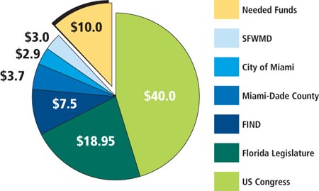 APPROPRIATED: APPROPRIATED:
US Congress: $42.08 million
Florida Legislature: $17.64 million
FIND (Florida Inland Navigational District): $6.68 million
Miami-Dade County: $3.7 million
City of Miami: $2.9 million
SFWMD (South Florida Water Management District): $3 million
TOTAL SO FAR: $76 million
NEEDED TO COMPLETE: $10 million*
* Figure is approximate. All dredging work so far has been on time and within budget.
|
|
COMMITTEE WORKING GROUP | BRUNO BARREIRO & MEGAN KELLEY, CO-CHAIRS
Economic Development |
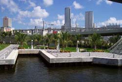
In July, the Miami-Dade County Commission approved Merrill-Stevens Dry Dock Company’s plans for a $55 million-plus expansion. The recreational boatyard has been in continuous operation on the Miami River since 1923.
The expansion, first announced in 2006, would include a 2,500-ton lift capable of removing 250-foot mega-yachts for servicing. The planned expansion requires completion of the Miami River maintenance dredging project to accommodate the larger recreational yachts Merrill-Stevens services.
The project would create 350 new jobs with salaries well above the county average, a marine vocational school, publicly accessible riverwalk/greenway sections, and a Miami River historical exhibit/museum area. Antonio Villamil and Charles Yaros of the Washington Economics Group prepared an independent economic analysis, which estimated a total annual recurring economic impact from the facility at $195 million.
The Economic Development and Commerce subcommittee is overseeing the creation of an independent Miami River Marine Industrial Economic Analysis, which Florida Atlantic University is scheduled to complete in 2008.
In addition, the Economic Development and Commerce Working Group recommends that Miami-Dade County create an “Upper River Plan” followed by Miami Intermodal Center Associated Development Specifications and Guidelines. The plan, specs and guidelines will provide the needed framework to steer appropriate intermodal connectivity between the Port of Miami River and adjacent Miami Intermodal Center, Miami International Airport and existing railroad lines.
|
|
|
COMMITTEE WORKING GROUP | DR. ERNEST MARTIN, CHAIR
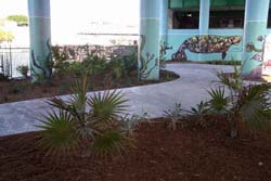
Greenways |
Greenways are a vital link in bringing the Miami River
to its full potential. Generally, its goals are to make the river more
accessible to the public, and the land more accessible to boaters.
Greenways systems have been successfully devised in Cleveland,
Chattanooga, and Providence, where public access, parks, paths, and
bikeways coexist with maritime uses.
Here is the Miami River Commission's vision on
Greenways: The Miami River is a valuable natural and historic
resource and the namesake of our community. We envision the Miami River
as an ecological system that serves to enrich the lives of residents
throughout the Miami metropolitan area. The Miami River Greenway will
help to improve the future economic well-being of our community by
increasing public access to the waterway, sustaining the "working
river" maritime shipping industry, restoring water quality in the
river channel, serving as an attractive destination for local residents
and visitors, encouraging appropriate adjacent land use, fostering an
ethic of stewardship for plants and animals native to the river
landscape, and celebrating the multicultural ethnicity of our community.
|
- Goals & Objectives
- Project Themes
- Accomplishments
in 2007
Our vision will be
realized in part through the adoption and implementation of these goals
and objectives:
GOAL 1: Improve
access to the river
GOAL 2: Sustain the "working river" industries of the Miami River
GOAL3: Restore
water quality throughout the river ecosystem
GOAL 4: Serve as a destination landscape for Metro Miami;
GOAL 5: Encourage a compatible land use vision for the river;
GOAL 6: Foster an ethic of stewardship for the river;
GOAL 7: Celebrate the multicultural diversity of adjacent neighborhoods. |
|
The
Miami River
is Our Home
The
Miami River
is a Working River
The
Miami River
is a Destination
The
Miami River
is an Environmental
Resource at Risk
The
Miami River
is an Economic Resource
The
Miami River
is of Our Heritage
|
The Miami River is our Home. The 69-square-mile Miami
River basin is home to an estimated 250,000 people. This multicultural
population interacts with the river landscape daily, and yet access to
the beneficial landscapes has been systematically limited by a
community-wide policy of fencing and under-programming of key public
landscapes. Few public gateways exist to encourage either visual or
physical interaction with the river. Local residents have become
increasingly isolated from this valuable resource. A Greenway system
would reconnect the diverse cultural and ethnic neighborhoods adjacent
to the river. The Greenway would link together neighborhoods with the
significant parks, public open spaces, historic sites and other
important destinations found along the river. This will enable people to
transport themselves by walking and cycling, to a multitude of
destinations along the 5-mile river.
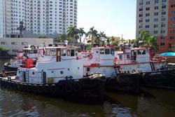
The
Miami River is a Working River. The Miami River is
equivalent of the 5th largest port in the State of Florida and the
source of most of the state's maritime trade with the Caribbean. Its
navigation and commercial shipping directly generates an estimated $4
billion in cargo annually. The Greenway will provide improved access to
the river to view the shipping industry at work and help to raise the
awareness of the importance of the river as a working river landscape.
The
Miami River is a Destination. Destination landscapes
attract people and activities. They generate a critical mass of people,
are attractive landscapes, and usually result in economic activity.
Although the Miami River has enough high-quality attractions to make it
a destination landscape, these are not linked together to generate a
critical mass of use. The proposed Miami River Trail and long-standing
Miami Riverwalk are the key elements in creating a successful
destination along the river. Connections to the river are also critical,
such as the proposed Overtown Safewalk, the Flagler Streetscape
improvements, and the linkages to East Little Havana and the Brickell
Corridor. Making Miami River friendlier and more conducive for tourism
and daily activity will require new investment in public and private
spaces. Access needs to be improved with gateways, bicycle and
pedestrian paths that flow from the downtown and adjacent residential
neighborhoods to the river.
The
Miami River is an Important Environmental Resource at Risk. The word
"Miami" means "sweet water". Although the River is
polluted today and supports industrial marine use, its
ecosystem requires urgent protection. Important species of plants and
animals still inhabit the river, with the manatee a symbol of an
ecosystem at risk. The Biscayne Bay is a direct recipient of the fresh
water flowing into the Miami River. The Bay is a valuable resource for
residents of South Florida, supplying recreation, tourism, and economic
opportunities. Less than 15 percent of South Florida's rainwater reaches
the Biscayne Bay Aquifer, the region's primary drinking water supply.
The rest of evaporated by the sun or drained by canals to the sea.
Between 1990 and 2010, the demand for public water supply is expected to
increase by 69 percent. Greenways can instill a new stewardship ethic
for this critically important resource.
The
Miami River is an Economic Resource. For all its potential
attractions, the river landscape has yet to realize major benefits from
Miami-Dade County's $11 billion-a-year tourism industry. While Miami is
one of the nation's great international financial centers, it is also
the fourth poorest major city per capita. Yet, while properties along
the Miami River have not kept pace with oceanfront and bayfront
locations, property values in the downtown section of the river have
risen dramatically. Proposed high-rise residences along the Brickell
corridor will bring higher-income households to the river corridor, and
transform the economics in the river's immediate vicinity. A Greenway
will make the river landscape accessible, attractive, and connected,
which in turn will continue to increase the value of property adjacent
to the riverbanks.
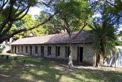
The
Miami River is of Our HeritageThe mouth of the Miami
River has been a focal point for human settlement and activity for more
than 2,000 years. A 2.2-acre site at the mouth of the river, called
Miami Circle, at Brickell Point, is all that remains of a native
American civilization archeological record. Efforts are afoot to protect
and properly interpret this unique landscape and the artifacts that have
been found on the site. This is just one of many points of historical
significance along the river. It is no exaggeration to call the river
the cradle of South Florida's history. |
In 2007
In partnership with the Trust for Public Land, the Florida Department of Transportation (FDOT), city and county, and riverfront developers, the MRC continued progress toward implementing The Miami River Greenway Action Plan (available at www.miamirivercommission.org).
In 2007 the public and private sectors continued developing the following sections of the publicly accessible Miami River Greenway system:
PUBLIC SECTOR:
• City of Miami, with grant funding from the Florida Department of Transportation, constructed an on-road Greenway section along North River Drive from I-95 to NW 2nd Street.
PRIVATE SECTOR:
• “Latitude on the River” riverwalk under construction
• “Mint” riverwalk under construction
• “Wind” riverwalk under construction
• “Terrazas Riverpark Village” riverwalk under construction
• “Miami River Oaks Marina and Condominium” riverwalk under construction
The south shore trailhead at the ancient Miami Circle site can only be created after the site’s collapsed seawall is replaced. The MRC continues to urge the state’s immediate repair of the seawall, followed by creation of the riverwalk to finally create public access to this site, purchased by the taxpayers in 1998 for $25 million.
MRC is continuing to coordinate and cosponsor volunteer cleanup and beautification of the Greenway with Hands on Miami, the University of Miami, Ransom Everglades, the Jewish Volunteer Center, the Junior League, Engage Miami and other groups.
The MRC continues to meet with the City of Miami administration regarding the needs for additional maintenance, security and special events, which are critical to ensure the Greenways’ success and longevity after completion. |
|
|
COMMITTEE WORKING GROUP | GARY WINSTON, ROBERT RUANO, CO-CHAIRS
Public Safety |
The Miami River Security Committee, coordinated by the Miami River Marine Group and hosted by the U.S. Coast Guard, continues to meet monthly and is focused on homeland security on the Miami River.
We thank Joe Piñon, former chair of the committee, for his service. He has moved to Iraq to work in the private sector.
The Miami River’s 20 internationally certified shipping terminals are implementing the Transportation Workers Identification Card (TWIC), which requires a thorough background check of all employees of the shipping terminals.
|
|
|
COMMITTEE WORKING GROUP | SALLEY JUDE, CHAIR
Stormwater |
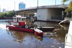
Storm water management is vital to the health and ecological safety of a major city prone to flooding and hurricanes. The main source of pollution in the Miami River and Biscayne Bay is the antiquated storm water and sanitary sewer system serving the 69-square-mile Miami River basin.
Environmental agencies– including the City of Miami, Miami-Dade Department of Environmental Resource Management and the Water and Sewer Department, South Florida Water Management District and the Florida Department of Environmental Protection – continued to implement the working group’s Miami River Basin Water Quality Improvement Plan. The city estimates a September 2008 completion of the design, permitting and public outreach for the dredging project within the Seybold Canal and Wagner Creek, two of the most polluted bodies of water in Florida.
The City of Miami has already retrofitted and repaired several old storm water systems and installed new solid waste interceptor baskets to prevent debris from entering the Miami River and Wagner Creek. In 2007, improved Total Maximum Daily Load (TMDL) water quality goals were established for Wagner Creek, which environmental agencies will strive to attain and exceed.
|
DOWNLOAD
the 2002 Stormwater Report Card
DOWNLOAD the Miami River Basin Water Quality Improvement
Report written
by the Miami River Commission's Stormwater Subcommittee including
representatives of the Environmental Protection Agency, the Florida
Dept. of Environmental Protection, Miami-Dade County Dept. of
Environmental Resource Management, City of Miami, and the Miami River
Commission.
|
|
COMMITTEE WORKING GROUP | JAMES MURLEY, CHAIR
urban Infill |
In 2007, the MRC adopted the Miami River Corridor Multimodal Transportation Plan in partnership with the Metropolitan Planning Organization (MPO), the Florida Department of Transportation (FDOT), city and county. The plan recommends multimodal transportation improvements to accommodate the significant growth of residents, tourists and freight along the Miami River.
A major recommendation of the multi-modal transportation plan would alleviate downtown truck traffic through implementing “short-sea shipping” operations linking the Port of Miami with the Upper River. Trucks would drop off and pick up their cargo containers at a marine industrial upper river site with access to SR 112, rather than drive through congested downtown streets to the Port of Miami. Then the containers would be barged to and from the Port of Miami overnight.
A pilot short-sea shipping program would result in transporting four barges with three containers every night, thereby removing 1,200 trucks per day from the downtown streets.
In addition, the plan recommends other multimodal transportation improvements, including, but not limited to: waterborne transit, synchronizing signals with drawbridge openings; two-waying certain one-way streets; a tugboat basin, a centralized freight-forwarding center, and more.
Mixed-use and mixed-income redevelopment continues, often on once-vacant and contaminated brownfield sites within the downtown lower river section of the Miami River corridor. Currently there are 3,373 residential units recently completed, 4,046 units under construction and 6,548 units in final permitting stages along the Miami River.
The Urban Infill Working Group has been encouraging the river corridor stakeholders to take additional steps toward consistency with Gov. Charlie Crist’s 2007 Energy and Climate Change executive orders to reduce our carbon footprint and create a more sustainable environment. These initiatives are consistent with the Miami River Commission’s 2005 Energy and Water Conservation Plan.
The Urban Infill Working Group is advocating for consistency between the Urban Infill Plan and the City of Miami’s draft Miami 21 zoning code rewrite, in addition to the Downtown Development Authority’s draft Downtown Miami Master Plan.
|
Miami Urban Corridor Urban
Infill Plan
A 154 page
redevelopment plan prepared for the Miami River Commission, City of Miami,
and Miami-Dade County incorporates a 10-year vision for the
Miami River with historical background and a summary of existing
conditions. It implements usage improvements for: bridges,
greenways, dredging, governance structures, partnerships, shipping, public
transportation, planning and zoning, environmental restoration, housing,
crime, public and private investment, and economic factors.
The Plan contains numerous photographs, aerials and maps; charts and
exhibits (some are downloadable below).
|
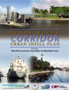
This is a large
document to download and print. Please be patient. Click on image above.
|
|
|
|
|
|
C/O Robert King High • 1407 NW 7 Street, Suite D, Miami, FL 33125 • 305-644-0544 • Fax: 305-642-1136 • Contact us email |
|